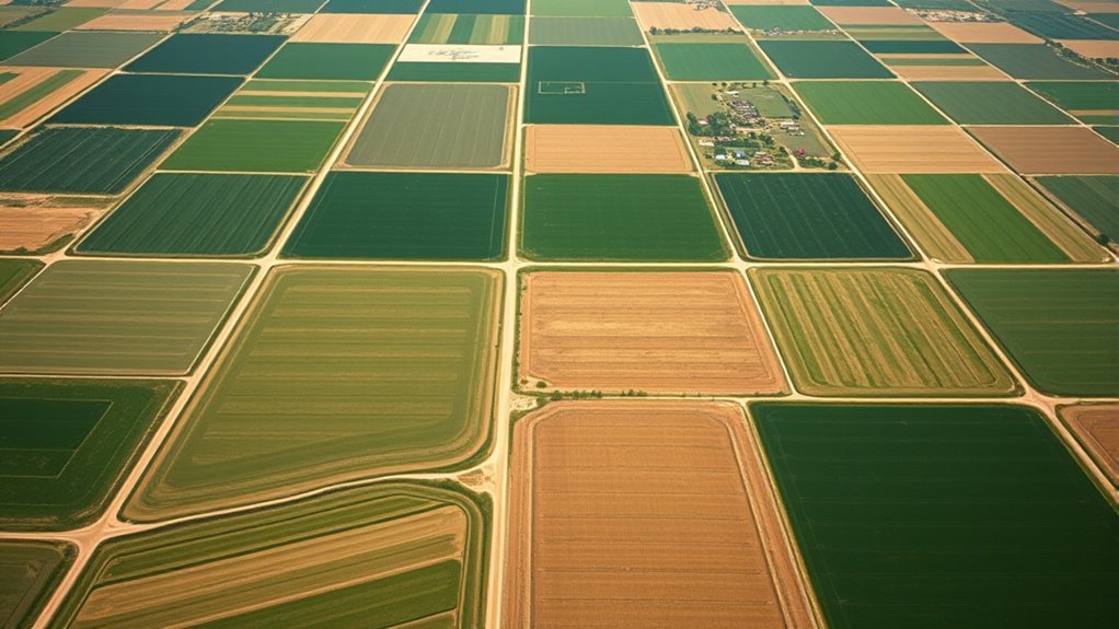

When land grants are given based on survey lines, it sets clear boundaries for farms. Surveyors measure and mark natural features or post boundary markers to define property lines, respecting indigenous land claims and preventing disputes. These precise measurements become official records, helping landowners maintain clear ownership. Over time, these boundaries shape farm layouts and regional development. If you’re curious about how this process created the farm landscapes you see today, there’s more to uncover.
Key Takeaways
- Land grants formalized ownership based on survey measurements and boundary markers.
- Surveys translated natural and indigenous boundaries into precise legal land descriptions.
- Boundary markers like posts or stones established clear property lines after grants.
- Physical markers served as tangible proof of land ownership and helped prevent disputes.
- These processes created organized farm boundaries, supporting land development and community growth.

Have you ever wondered how land boundaries are determined and mapped? When settlers arrived, they often relied on the history of Native Land to understand the origins of the land. Native tribes had long established their territories, using natural landmarks and boundary markers to define their domains. These boundary markers could be trees, rocks, or other natural features that served as clear indicators of tribal borders. Recognizing these markers was essential for respecting indigenous rights and avoiding conflicts. As newcomers laid claim to land, they frequently used these existing boundary markers as reference points, guaranteeing they respected previous claims while establishing their own.
Native boundary markers like trees and rocks helped settlers respect indigenous land claims.
When you consider how farms formed, it’s important to realize that surveys played a critical role in translating these natural and Indigenous boundaries into legal land descriptions. Surveyors would carefully measure and map the land, often marking boundaries with physical boundary markers like posts, stones, or fences. These boundary markers provided a tangible way to delineate property lines, making ownership clear and enforceable. The process of setting boundary markers was meticulous, involving precise measurements to guarantee that land grants matched the actual land being surveyed. This accuracy was essential because it prevented disputes and made land transactions more straightforward. Survey lines served as the foundation for establishing clear property boundaries.
Land grants, often issued by government authorities or land commissioners, formalized claims to land based on these surveys. Once a land grant was issued, the surveyor’s boundary markers became the official markers that defined the farm’s limits. These markers served as a permanent reference, standing as physical proof of ownership and helping future landowners maintain clear boundaries. Over time, these boundary markers became an integral part of the landscape, guiding farmers, surveyors, and landowners in maintaining their property lines.
Understandably, the process of mapping land from Native Land and establishing boundary markers created a foundation for farm development. The intersection of indigenous land boundaries, legal grants, and physical markers shaped the way farms expanded and organized across regions. These boundary markers weren’t just about land; they represented respect for prior claims and the practical need for clear, enforceable borders. As farms grew and land was subdivided, the importance of well-placed boundary markers and accurate surveys became even more apparent, guaranteeing that ownership remained clear and disputes minimized. Ultimately, this careful process of mapping, marking, and honoring Native Land helped create the organized, structured farms that form the backbone of many rural communities today.

4Pcs Low Profile Survey Stakes 7“ with High-Visibility Color, Larbeti Heavy Duty Survey Markers Stakes for Permanent Property Line Markers, Land Boundary Record for Earthwork (2P Orange and 2P Red)
【Precision Ground Control】 Low profile survey stakes surveying strike plate has 2 high-performance viewing colors, orange and red,…
As an affiliate, we earn on qualifying purchases.
As an affiliate, we earn on qualifying purchases.
Frequently Asked Questions
How Did Indigenous Land Rights Influence Early Land Grants?
You should know that indigenous land rights greatly influenced early land grants by prompting negotiations and conflicts over territory. When settlers received early land grants, they often had to respect or navigate indigenous claims, which shaped boundaries and land use. Recognizing indigenous land rights forced authorities to adapt grants, sometimes leading to treaties or disputes, ultimately impacting how farms and settlements developed across the region.
What Role Did Natural Features Play in Survey Line Placements?
Imagine natural landmarks like rivers and hills as the guiding stars of your land. You’d place survey lines along water boundaries and prominent features, trusting these natural markers to define property limits. These features symbolize stability and continuity, shaping the layout of farms. By following natural landmarks, surveyors guaranteed that boundaries reflected the landscape’s true essence, helping landowners feel connected to their land’s natural identity and creating clear, lasting divisions.
Were There Any Disputes Over Land Boundaries Historically?
Yes, you’d encounter boundary disputes and settlement conflicts historically. These conflicts often arose when survey lines didn’t match natural features or when settlers misinterpreted land grants. Disputes could lead to legal battles or violence, especially as land was valuable for farming and settlement. Clear boundaries helped prevent these issues, but misunderstandings and inaccuracies still caused many boundary disputes in early settlement days.
How Did Survey Inaccuracies Affect Land Ownership Over Time?
Sometimes, survey errors led to boundary shifts that caused confusion over land ownership. These inaccuracies, though often subtle, could change property lines over time, making it tricky to settle disputes. You might find that small mistakes in measurements accumulated, creating lasting effects. As a result, landownership could become somewhat fluid, requiring ongoing adjustments and negotiations to respect the original intent and maintain harmony within communities.
What Technological Advancements Improved Survey Accuracy?
You see, technological advancements like improved surveying tools and measurement techniques dramatically increased survey accuracy. Tools such as the theodolite and later, electronic distance measurement devices, allowed you to measure angles and distances precisely. These innovations reduced errors caused by manual calculations, ensuring land boundaries were more accurate. As a result, land ownership became clearer, and disputes decreased, making the surveying process more reliable for establishing farm and property boundaries over time.

ZL190PLUS Land Surveying Equipment, Handheld GPS for Surveying with 3.2 Inch Color Screen, Multi-GNSS Support, 7 Measuring Models for Measuring Land Area, Length,Slope and Save Coordinates Points
Large Screen:Large 3.2" sunlight-readable color display with 240 x 320 display pixels for improved readability,even in bright sunlight
As an affiliate, we earn on qualifying purchases.
As an affiliate, we earn on qualifying purchases.
Conclusion
Understanding how land grants and survey lines shape farms helps you see the roots of rural landscapes. Imagine you’re walking through a historic farm, noticing the straight lines dividing fields—these are the survey lines that once defined land grants. Just like the Johnson family’s farm, established on carefully surveyed land, your farm’s layout reflects past decisions. Recognizing this connection helps you appreciate the history embedded in every acre you tend today.
ZL190PLUS Land Surveying Equipment, Handheld GPS for Surveying with 3.2 Inch Color Screen, Multi-GNSS Support, 7 Measuring Models for Measuring Land Area, Length,Slope and Save Coordinates Points
Large Screen:Large 3.2" sunlight-readable color display with 240 x 320 display pixels for improved readability,even in bright sunlight
As an affiliate, we earn on qualifying purchases.
As an affiliate, we earn on qualifying purchases.

50 Pack Fixed Insulator Fiberglass Posts, 48 Inch Fiberglass Electric Fence Posts, Easy Step-in Posts for Livestock Fencing, Garden Fencing and Boundary Marking
Durable and Lightweight: This 48-inch electric fence post is ideal for temporary pasture fencing, seasonal garden fencing, and…
As an affiliate, we earn on qualifying purchases.
As an affiliate, we earn on qualifying purchases.